The Emlid Reach RS2+ is one of the most common receivers we see on WizNET. Connected to our network, it gets RTK corrections over the internet, so you can collect points with centimetre-level accuracy without setting up your own base station.
This guide walks through the connection in the Emlid Flow app, which mountpoint to choose, how to confirm you have a fixed solution, and how to use the Reach as a base for an RTK drone. It is based on our Emlid setup instructions.
Key Takeaways
- The Reach connects to WizNET through NTRIP in the Emlid Flow app, using the details in your WizNET welcome email.
- Choose a VRS mountpoint for most work, or the nearest single base if the VRS solution is not available.
- Only start measuring when the app shows FIX, not Float or Single.
- Kinematic mode is for collecting points and GCPs; Static mode is for using the Reach as a base.
- WizNET covers Vancouver Island, the Sunshine Coast, Sea to Sky, Greater Vancouver, the Fraser Valley, Merritt and the Okanagan.
Before You Start
- A WizNET subscription. Your welcome email contains the server address, port, username and password. Plans are available monthly or annually.
- The Emlid Flow app on your phone or tablet, connected to the Reach.
- An internet connection for the Reach, usually your phone’s hotspot or a site Wi-Fi network.
- A location inside the coverage area. Check the WizNET coverage map before heading out.
Connect the Reach to WizNET
- Open the Emlid Flow app and connect to your Reach RS2+.
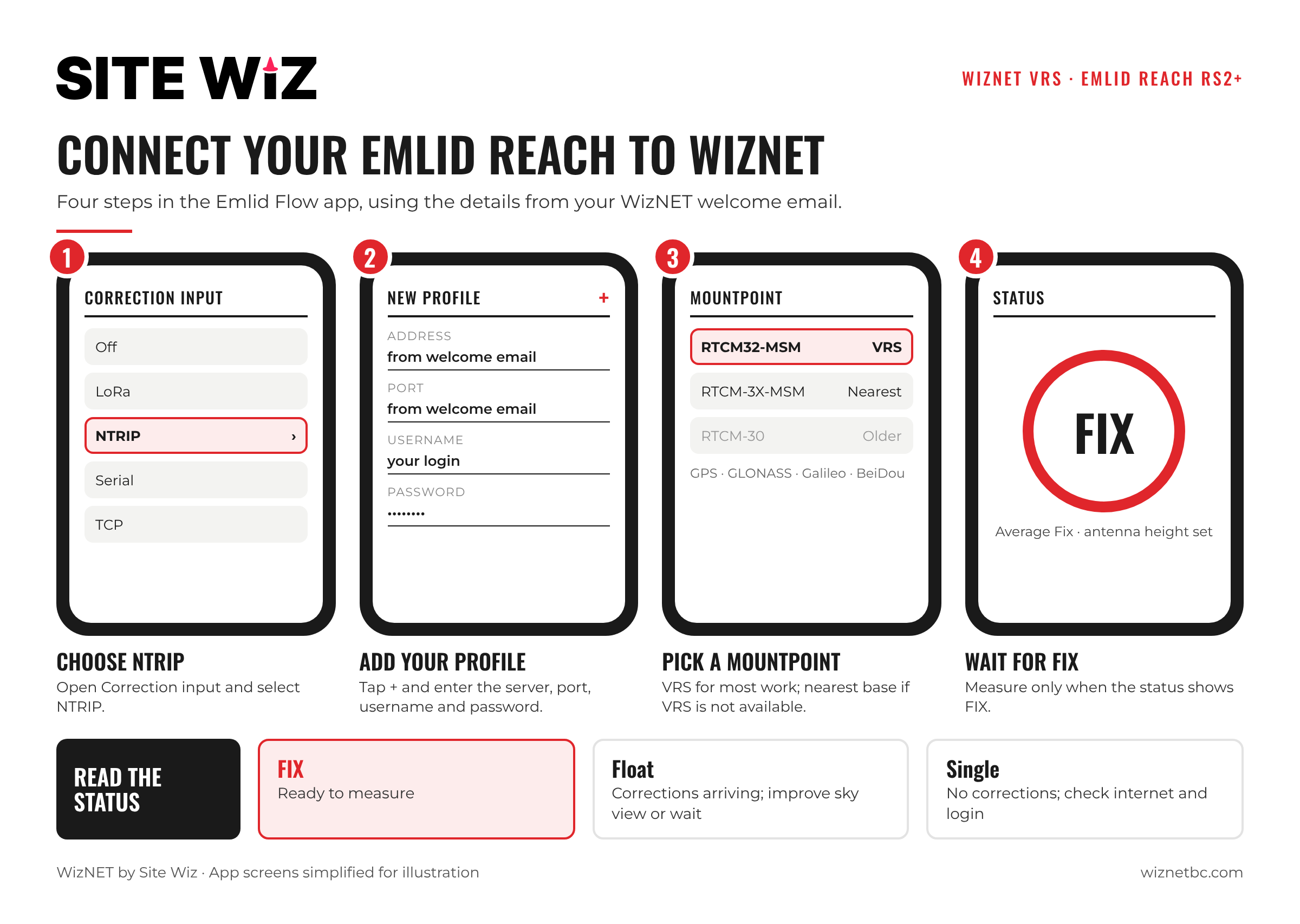
- Open Correction input and select NTRIP.
- Tap the + icon in the top left corner to add a new profile. Emlid Flow keeps several profiles, so you can switch between correction services easily.
- Enter the details from your WizNET welcome email: server address, port, username and password.
- Save the profile. The app requests the list of available mountpoints from the network.
Choose a Mountpoint
WizNET offers two types of correction stream:
- VRS (Virtual Reference Station): the network creates a virtual base close to your position. This is the best choice for most work. On WizNET it is listed as RTCM32-MSM.
- Single baseline: corrections from the nearest physical reference station, listed as RTCM-3X-MSM. Useful if the VRS solution is not available where you are.
Older receivers may need the RTCM-30 streams instead, but only use them if the two above do not work. Both stream types support GPS, GLONASS, Galileo and BeiDou.
Check for a Fixed Solution
Once corrections are arriving, the status in the top left corner of the app should change to FIX. This means the Reach is combining satellite signals with WizNET corrections for a centimetre-level position.
- FIX: ready to measure.
- Float: corrections are arriving but the solution has not resolved. Wait, improve the sky view, or check the mountpoint.
- Single: no corrections are being used. Check the internet connection and the NTRIP details.
Settings for Collecting Points
- Set point averaging to Average Fix, so only fixed epochs are used.
- Enter the correct antenna height and choose an averaging time that suits the job.
- In Settings → GNSS settings, set Positioning mode to Kinematic when you are moving the Reach to collect points or ground control points.
You are now ready to start a new project. For anything not covered here, see the Emlid user manual.
Using the Reach as a Base for an RTK Drone
The Reach can also pass WizNET corrections on to an RTK drone, which is useful for mapping and volume surveys.
- In GNSS settings, set Positioning mode to Static.
- Set up a Base output. For DJI drones, select Local NTRIP.
- Connect the Reach and the drone’s controller to the same internet connection. A phone hotspot works, but you need to stay close to the Reach.
- In the DJI camera view, open the RTK menu and enter the details shown by the Reach.
Troubleshooting
- No mountpoints appear: check the server address, port and that the Reach has internet.
- Stuck in Single: the login or mountpoint is wrong, or the data connection has dropped.
- Stuck in Float: move away from trees, buildings or steep slopes, and give the receiver time. Try the other mountpoint type.
- Fix drops in and out: usually a weak cell signal or a blocked sky. Our guide on multi-constellation GNSS in BC covers working in difficult spots.
Still having trouble? Contact the WizNET team and we will help you get connected.
Frequently Asked Questions
Which Emlid receivers work with WizNET?
This guide uses the Reach RS2+. Other Emlid receivers that accept NTRIP corrections connect in a similar way through Emlid Flow.
Do I need my own base station?
No. WizNET provides the corrections, so a single Reach works as a rover. You only set up a base if you want to pass corrections to a drone.
Which mountpoint should I use?
Start with the VRS mountpoint (RTCM32-MSM). If it does not work in your area, use the nearest single base (RTCM-3X-MSM).
Where does WizNET work?
Vancouver Island, the Sunshine Coast, the Sea to Sky corridor, Greater Vancouver, the Fraser Valley, Merritt and the Okanagan from Kamloops to Osoyoos.
How much does WizNET cost?
See the current monthly and annual plans.