Why are you still spending the first hour of every shift guarding a tripod in the middle of a high-traffic British Columbia job site? You realize that traditional workflows involving a GNSS network for construction surveying are often a significant drain on project timelines, especially when you factor in the constant risks of equipment theft, signal interference in urban centres, or the unpredictable multipath errors found in mountainous terrain. It’s a common frustration for site supervisors who need to maintain tight tolerances but find themselves hampered by hardware maintenance and inconsistent corrections.
By leveraging WizNET VRS, you can finally eliminate the overhead of physical base stations while achieving the centimetre-level accuracy your engineering projects demand. This resource details how modern correction services are revolutionizing site workflows across BC. We’ll explore how to streamline data collection for machine control, ensure absolute consistency across expansive linear projects, and unlock maximum field performance regardless of your equipment’s brand. You’ll discover how to transition from managing hardware to mastering data precision.
Key Takeaways
- Transition from manual site measurements to real-time digital positioning by adopting a GNSS network for construction surveying to modernize your field workflows.
- Understand the technical mechanism of Virtual Reference Stations (VRS) and how they eliminate the need for physical base station setups while maintaining centimetre-level precision.
- Discover specialized strategies for maintaining reliable signal locks and consistent accuracy within British Columbia’s complex urban centres and mountainous landscapes.
- Realize significant project ROI by replacing the high overhead of base station maintenance with a scalable, hardware-agnostic RTK network subscription.
- Learn how to integrate multi-constellation GNSS data with existing site control points to ensure seamless coordination across large-scale linear projects.
Modernizing Field Work: The Role of GNSS Networks in Construction
A professional GNSS network for construction surveying is no longer just a luxury for large-scale infrastructure projects; it’s the foundation of the modern digital job site. In its simplest form, this network consists of a coordinated infrastructure of permanent, high-precision reference stations that continuously stream satellite data to a central server. By moving away from manual site measurements and tape-and-transit methods, firms are adopting real-time digital positioning to maintain the rigorous standards expected in 2026. This shift is driven by the upcoming transition to the North American Terrestrial Reference Frame of 2022 (NATRF2022), which necessitates far greater precision than standard GPS can provide alone. Relying on a robust geodetic control network ensures that every coordinate captured on-site aligns with these updated national standards.
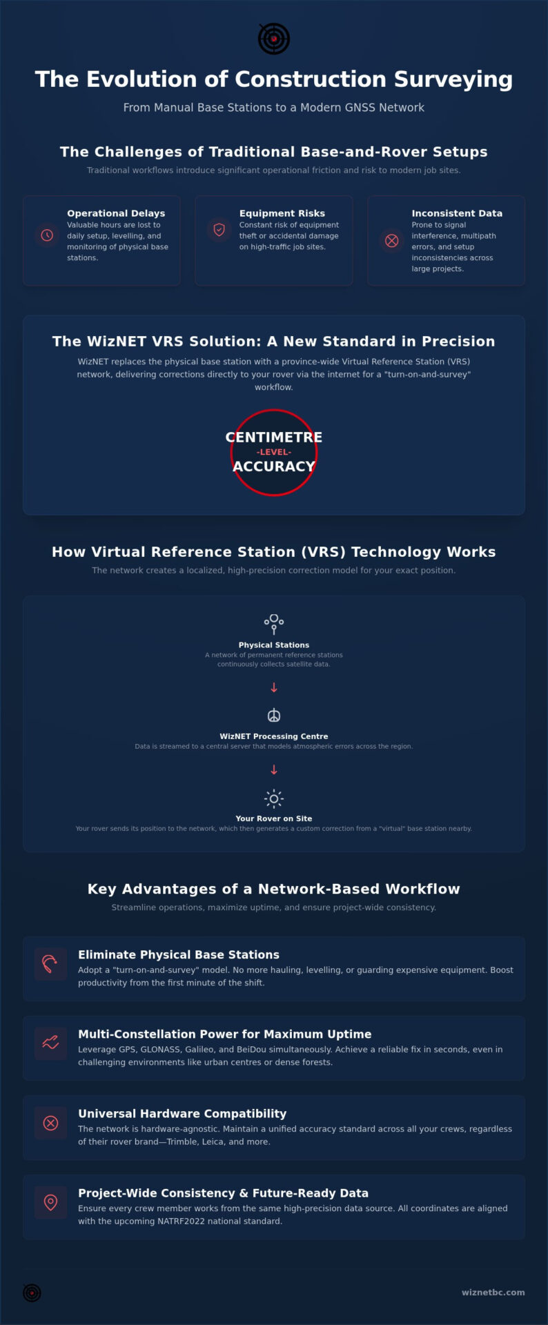
While traditional base-and-rover setups served the industry for decades, they introduce significant operational friction. A network-based workflow replaces the localized base station with a broad, reliable correction service that covers the entire project area. This evolution allows site supervisors to move from reactive troubleshooting to proactive management. You gain the ability to verify grade, stake out utilities, and monitor progress with a level of speed that traditional methods cannot match. Precision is now an infrastructure service rather than a hardware burden.
Beyond GPS: The Multi-Constellation Advantage
Success on a complex site depends on satellite availability. Utilizing a multi-constellation approach that incorporates GPS, GLONASS, Galileo, and BeiDou simultaneously is now a non-negotiable requirement for professional surveying. By tracking dozens of satellites rather than a handful, rovers achieve a reliable “fix” in seconds rather than minutes. This increased availability is particularly critical in British Columbia, where deep urban canyons in Vancouver or dense tree cover in the interior often obstruct clear views of the sky. More satellites mean less downtime. When your equipment can access every available constellation, you maintain productivity in environments where older, GPS-only systems would simply fail to initialize.
Eliminating the Private Base Station
The traditional base-and-rover setup is becoming a relic of the past. Modern network RTK workflows allow crews to leave the heavy tripods and external radios at the office. You no longer need to spend valuable morning hours hauling, levelling, or guarding expensive tripod-mounted bases against theft or accidental knocks. Instead, a “turn-on-and-survey” model allows rovers to receive corrections instantly via the internet. This approach provides unmatched consistency across large sites because professional GNSS corrections BC services model atmospheric errors across the entire province. By removing the variable of local base station setup errors, you ensure that every crew member works from the same high-precision data source, regardless of where they are on the project alignment.
Multi-Constellation VRS: Achieving Centimetre Precision
A high-performance GNSS network for construction surveying does more than simply relay satellite signals; it actively computes a customized correction for your specific location. Through Virtual Reference Station (VRS) technology, the network receives your rover’s approximate position and interpolates data from surrounding physical stations to “create” a virtual base station just metres from your receiver. This mathematical model effectively neutralizes atmospheric interference, such as ionospheric and tropospheric delays, which are the primary culprits behind positioning errors. By modelling these errors in real time, the system delivers the centimetre-level horizontal and vertical precision required for sensitive foundation work and complex grading. If you’re looking to upgrade your field performance, you might consider how WizNET VRS can streamline your next layout.
One of the most empowering aspects of a professional network is its hardware inclusivity. Whether you’re operating a premium Trimble R12i, a Leica GS18 I, or a budget-friendly alphageo unit, the system remains hardware-agnostic. This flexibility allows firms to mix and match equipment types across different crews while maintaining a unified accuracy standard. It eliminates the frustration of being locked into a single manufacturer’s ecosystem, allowing you to maximize the potential of your existing fleet regardless of the hardware’s age or brand.
How VRS Corrections Reach the Rover
Reliable delivery of correction data relies on the NTRIP protocol, which streams information via cellular networks directly to your rover’s internal modem or a connected controller. Low-latency transmission is absolutely critical here, especially for high-speed machine control applications where a delay of even a few seconds can result in significant grading errors. Ensuring data integrity through a robust RTK network infrastructure BC professionals trust is the only way to maintain the steady flow of information needed for automated site equipment. When latency is minimized, your machinery can react instantly to design changes in the digital model.
Precision Standards for Site Engineering
In the field, the distinction between “mapping grade” and “survey grade” is the difference between a project’s success and a costly rework. While mapping grade might suffice for general asset tracking, site engineering demands survey-grade accuracy, typically defined as sub-two-centimetre precision. Vertical accuracy is the true test of any network, as it’s far more susceptible to satellite geometry issues than horizontal positioning. A professional network uses redundant reference stations to ensure that if one station goes offline, the system automatically recalculates corrections from others. This redundancy prevents network outages and keeps your crews moving without interruption.
Strategic Site Implementation: Control Networks and Signal Reliability
Implementing a GNSS network for construction surveying requires a strategic approach to bridge the gap between global satellite coordinates and local site design. While the network provides a high-precision absolute position, you must integrate this data with established site control points to ensure every stakeout aligns perfectly with the project’s blueprints. This process typically involves a “localization” or “site calibration,” where you measure known physical benchmarks to resolve the differences between the national geodetic grid and the local site grid. By performing this step at the project’s outset, you establish a reliable mathematical link that maintains consistency throughout the construction lifecycle. You don’t want to discover a three-centimetre bust halfway through a foundation pour because of a transformation error.
Establishing a Robust Site Grid
Your first task on any new project is verifying the RTK network coverage map BC to confirm signal density in your specific region. Once coverage is confirmed, you should set out permanent, stable benchmarks that serve both GNSS and total station hybrid workflows. These physical points act as an insurance policy. They allow you to cross-check your network solution daily, ensuring that atmospheric conditions or satellite geometry haven’t introduced subtle biases. For large-scale linear projects like highway expansions, these benchmarks are essential for maintaining vertical accuracy across several kilometres of terrain. By verifying your rover against a known point every morning, you eliminate uncertainty and build a defensible record of your site’s spatial integrity.
Overcoming Environmental Obstructions
British Columbia presents unique geographic hurdles, from the high-rise corridors of the Lower Mainland to the dense evergreen canopies of the Interior. Signal multipath errors occur when satellite signals bounce off buildings or trees before reaching your rover, leading to “float” solutions or centimetre-level drifts. To combat this, modern multi-constellation support uses a higher volume of satellites to filter out reflected signals and maintain a “fixed” status. When working in tight spots, pairing your GNSS network for construction surveying with tilt compensation technology allows you to capture points at the base of structures or inside trenches without needing a perfectly level pole. This combination unlocks maximum efficiency in even the most obstructed environments. If you’re ready to optimize your site’s precision, connect with WizNET for reliable RTK network access across the province.
Optimizing Project ROI with Professional GNSS Network Access
Investing in a GNSS network for construction surveying transforms how firms manage their capital. Instead of sinking significant funds into physical base stations that depreciate and require constant calibration, companies are shifting toward an operational expense model. This allows for rapid scaling. You can equip five crews with rovers for the price of two traditional base-and-rover setups. By removing the “dead time” associated with base station maintenance and setup, you increase billable hours and accelerate project delivery. Precision becomes a predictable utility rather than a variable hardware cost.
Centralized corrections also improve data consistency across various project phases. When the earthworks team, the utility installers, and the final grading crew all utilize the same GNSS network for construction surveying, coordinate drift is virtually eliminated. This unified approach ensures that the digital twin of the project matches the physical reality on the ground. As we approach the geodetic datum shifts of 2026, having a network provider handle the complex coordinate transformations is the most reliable way to future-proof your operations.
Subscription Value for BC Surveying Firms
Choosing a VRS network access subscription is a strategic move to mitigate site-specific risks. In British Columbia, equipment theft from active construction sites is a persistent headache. When you eliminate the tripod-mounted base, you eliminate a high-value target. You also gain the peace of mind that comes with 24/7 network monitoring and professional technical support. The network provider handles the complex geodetic math and hardware uptime, so your team can focus exclusively on production. It’s a shift from managing infrastructure to mastering field performance.
Machine Control and Automated Grading
The future of the industry lies in automated precision. By integrating WizNET VRS directly into excavators and dozers, you ensure that every bucket of earth is moved according to the digital design. This centralized correction stream reduces “re-work” by keeping all machinery on a unified coordinate frame. Real-time data corrections also facilitate instant “as-built” verification. As the operator works, the system captures points, allowing you to confirm grade without waiting for a surveyor to walk the site. This level of integration is essential for firms preparing for the 2026 shift toward fully autonomous machine control. You don’t just work faster; you work with a level of accuracy that older methods cannot replicate.
Mastering Precision on the Modern Job Site
Adopting a professional GNSS network for construction surveying is no longer just about accuracy; it’s about operational agility. By moving to a base-station-free model, you eliminate significant field overhead and security risks while ensuring every crew member works from a unified, high-precision coordinate frame. You’ve seen how localized corrections and multi-constellation support, including Galileo and BeiDou, provide the reliability needed for complex British Columbia projects. This approach doesn’t just improve your immediate layout; it future-proofs your firm against upcoming datum shifts and the rise of autonomous machinery.
WizNET provides the infrastructure to unlock your team’s maximum potential through hardware-agnostic RTK corrections and unmatched network reliability. It’s time to replace the frustration of localized base station maintenance with the stability of centimetre-level accuracy across every site. Upgrade your site precision with a WizNET VRS subscription today and lead your projects with technical authority. You’re ready to elevate your professional standards and streamline your path to success.
Frequently Asked Questions
What is the difference between a GNSS network and a standard GPS receiver?
A standard GPS receiver only tracks the American constellation and typically provides autonomous accuracy measured in metres. In contrast, a GNSS network for construction surveying utilizes multiple satellite constellations, including GLONASS, Galileo, and BeiDou, to provide real-time kinematic (RTK) corrections. The network acts as a distributed infrastructure that eliminates the need for your own base station while correcting for atmospheric errors that a standalone receiver cannot account for.
How accurate is a GNSS network for construction layout compared to a total station?
Total stations offer sub-millimetre precision over short distances, but a GNSS network provides consistent centimetre-level horizontal and vertical accuracy across the entire site without line-of-sight requirements. While a total station is superior for high-precision bolt patterns or structural steel, the GNSS network is the most efficient tool for site grading, utility layout, and large-scale earthworks. It allows one operator to cover significantly more ground than a two-person total station crew.
Can I use my existing Leica, Trimble, or Topcon equipment with a third-party VRS network?
You can absolutely utilize your existing Leica, Trimble, or Topcon receivers because professional VRS networks are hardware-agnostic and use standardized NTRIP protocols. Most modern survey-grade rovers are designed to be compatible with third-party correction streams regardless of the manufacturer’s brand. This flexibility allows you to maintain a diverse equipment fleet while standardizing your correction source, ensuring that every crew on the project operates within the same high-precision coordinate framework.
What happens to my survey accuracy if I lose cellular connection on a BC site?
If you lose cellular connectivity on a BC site, your receiver will eventually lose its “fixed” status as the real-time correction stream is interrupted. Many professional rovers feature internal technology that can maintain centimetre-level accuracy for several minutes during brief outages. For remote areas in the BC Interior with zero cellular coverage, you may need to utilize a physical base station or satellite-delivered corrections until a stable internet connection is restored to the rover.
Is a GNSS network subscription worth it for small-scale residential construction projects?
A subscription is highly beneficial for small-scale residential projects because it eliminates the time-consuming process of setting up and securing a private base station every morning. By using a rover-only setup, a single technician can quickly verify lot boundaries, stake out foundation corners, and check grade elevations in a fraction of the time. The reduction in labour costs and the elimination of hardware maintenance often allow the subscription to pay for itself within just a few projects.
How does a multi-constellation GNSS network help in urban environments with signal interference?
Multi-constellation support significantly improves performance in urban environments by increasing the total number of available satellites, which helps overcome signal “multipath” errors caused by reflections off high-rise buildings. When your receiver can track Galileo and BeiDou alongside GPS, it maintains a reliable position in narrow streets or near heavy foliage where a GPS-only unit would fail. This redundancy ensures that your GNSS network for construction surveying remains functional even when the sky is partially obstructed.