Vancouver Island is one of the hardest places in Canada to run RTK. Tall second-growth Douglas-fir, cedar and hemlock, steep slopes and long stretches of wet weather all work against a clean satellite signal. Yet much of the work here happens exactly in those conditions: forestry roads, cut blocks, utility corridors and residential lots full of big trees.
This guide explains why tree canopy makes RTK difficult and the field tactics that help you get, and keep, a reliable fix under trees with WizNET.
Key Takeaways
- Canopy weakens and reflects satellite signals, so the receiver has fewer clean measurements to fix with.
- Tracking GPS, GLONASS, Galileo and BeiDou gives you more satellites to work with through gaps in the trees.
- Small changes help: a taller pole, a few metres’ move to a gap, more time on the point, and planning around satellite geometry.
- When GNSS cannot hold a fix, set control in the open and finish under canopy with a total station.
- Always check a known point after working in heavy cover.
Why Trees Make RTK Hard
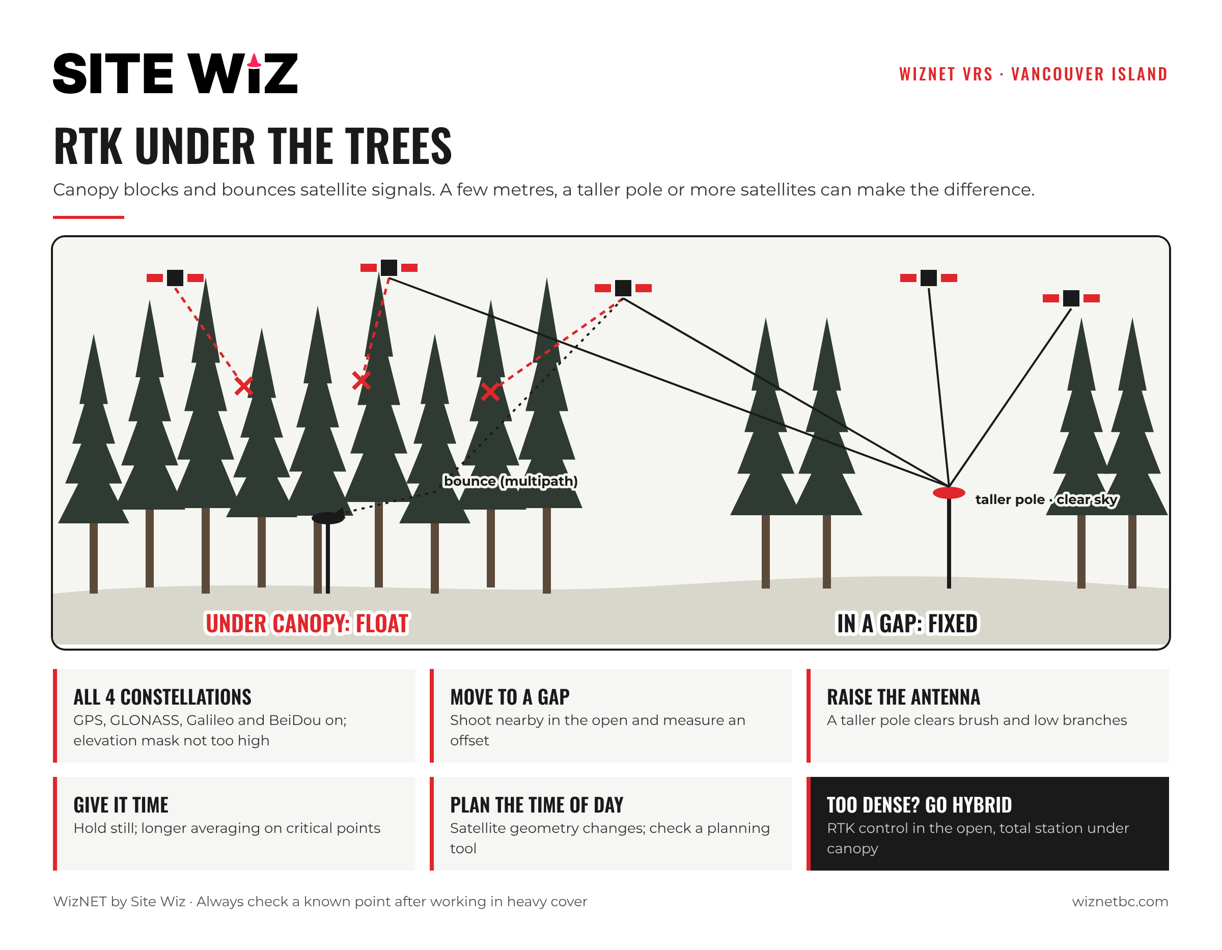
RTK needs clean carrier-phase measurements from many satellites at once. Under canopy, three things go wrong:
- Attenuation: trunks, branches and needles weaken the signal. Wet foliage weakens it further, which is why the same spot can behave differently on a dry and a rainy day.
- Blockage: large trees hide whole parts of the sky, leaving satellites bunched in a few gaps. Poor geometry makes the solution weak.
- Multipath: signals bounce off trunks and the ground before reaching the antenna, adding errors that can stop a fix or, worse, produce a wrong one.
The result is a rover that takes longer to fix, drops to Float as you move, or reports a fix that does not check on a known point.
Field Tactics That Work
Track every constellation
More satellites mean more chances that enough of them line up with gaps in the canopy. WizNET supports GPS, GLONASS, Galileo and BeiDou. Make sure all four are enabled on your receiver and that the elevation mask is not set higher than it needs to be.
Find the best spot, not the exact spot
Moving a few metres into a gap can turn Float into Fixed. If the point itself is under heavy cover, shoot nearby in the open and measure an offset, or use a receiver with tilt compensation to reach into the gap while the pole leans.
Raise the antenna
A taller pole lifts the antenna above understory brush and low branches, opening more of the sky. Remember to enter the correct antenna height.
Give it time
Under trees, a fix can take noticeably longer than in the open. Hold the pole still and level, and use longer averaging on critical points.
Plan around satellite geometry
Satellite positions change through the day. A spot that will not fix at 10 a.m. may fix easily an hour later. GNSS planning tools show when the most satellites will be above your site.
Watch the data connection
Forested valleys often have weak cell coverage. If the correction age keeps climbing, the problem is the connection, not the trees. Our guide on RTK Float vs Fixed has a full troubleshooting checklist.
When to Switch to a Total Station
Some spots will never give a reliable GNSS fix: deep in old-growth, against a cliff, or under dense second growth on a north slope. In those cases, the usual approach is a hybrid workflow:
- Set two or more control points with RTK in nearby openings, where the fix is solid and checks well.
- Set up a total station on those points.
- Measure the points under canopy conventionally.
This keeps everything on the same coordinate system while using each tool where it works best.
Checking Your Results
Heavy multipath can occasionally produce a fix that is wrong. After working under canopy, and after any long loss of fix, re-observe a known point or re-shoot a point you measured earlier. If the two do not agree within your tolerance, re-initialize and measure again.
WizNET on Vancouver Island
WizNET has reference stations from Victoria up the east coast to Campbell River and out to the West Coast, as well as on the Sunshine Coast, in the Sea to Sky corridor, Greater Vancouver, the Fraser Valley, Merritt and the Okanagan. See the coverage map for station locations.
New to WizNET? Our setup guides for Emlid Reach and Topcon get you connected, and plans are available monthly or annually.
Frequently Asked Questions
Can RTK work under forest canopy?
Often, yes, especially with all four constellations tracked and a little patience. Under very dense cover, a hybrid GNSS and total station workflow is more reliable.
Why is my fix worse when it rains?
Wet foliage weakens satellite signals more than dry foliage, so the receiver has less to work with.
Does a taller pole really help?
It can. Lifting the antenna above brush and low branches opens up more sky.
How do I know a fix under trees is right?
Check a known point or re-measure a point you shot earlier. If they agree within tolerance, the fix is good.